Wednesday, May 2, 2012

I let the sun beat me up this morning, but not by much. Today I will stay home, catch up on mundane adobe chores, a little painting and rest and ice my knee. It is still too windy to paint outside, but otherwise is a beautiful day, enjoyed by the steady stream of RV'ers pulling into the Painted Desert Inn across the street.

Late in the afternoon I can resist it no more. The wilderness below the PDI is calling me. I gather drawing materials and gingerly navigate the switchbacks down to the Painted Desert, telling myself to just keep on even ground and don't go too far.  And don't keep wrenching my knee like I was doing. And avoid climbing over large rocks. Except for these.


But most of the time I can navigate around the pillow-like rocks, fields of shale, and chunks of black petrified wood. I skirt the "foothills" below the ridge, dipping into drainages, most which turn out to be dead ends, but one that contains a treasure of petrified logs inset with quartz crystals.


Before going too far I find a spot to draw. Since my pad was too big for my pack I was going to carry it under my arm and grab it just as I went out the door. WAS going to grab it. FORGOT to grab it.

So a bit bummed, I decide to scrap my plan of sitting quietly drawing and instead explore the rocky terrain which is like a stairway drawing by M.C. Escher. Just when I think I'm at "ground level" I come to a cliff and have to backtrack, only to find myself in a high walled gully, which I  follow only to find myself at the base of the same cliff.

The sun is getting low in the west but I figure I still have a few hours to ramble before heading back up to the Painted Desert Inn. High on the mesa, its visible most of the time from the desert below, and I been within sight of it not long ago. A thin cloud covers the sun and the light dims, which causes me to nervously take stock of where I am. Of course I know in general, but its just the kind of lost I would get, within sight of my destination but hitting dead ends and not able to get there. So I start making my way back. The sun strengthens, the terrain looks familiar and I relax and climb a high shale-covered hill to sit and watch the light change as the sun approached the horizon.


I head back through formations glowing with heat and sun under a deep blue sky and cold white moon, climb the switchbacks in the dusk and sit at Kachina Point overlooking the desert for a long time.

Tuesday, May 1, 2012

After using my homemade pochade paintbox in the field, I've thought of some modifications that might make setup easier. One was to make an indent in the palette to clip in a palette cup. That would also allow me to set out my paints ahead of time and the cup would prevent the palette from touching the lid when closed.  Of course I have no tools, but I do have a single edge razor blade so I proceed to score and cut away at my masonite palette.  Once that's done I set out my colors, close the box and head out for the tepees. (I'll post my modified pochade box on my blog art and nature when the box I shipped from PEFO comes back to me and I perfect it)

The last pullout before crossing Route 40 is the Route 66 marker which always attracts an interesting mix of people. Besides the three major groups of PEFO, foreign tourists, school field trips and retirees, the mystique of "The Mother Road" attracts wanderers and motorheads. As I approach it seems like there are two big groups of motorcycles in the lot. As I get closer I realize that one of the groups is the motorcyclists, not motorcycles, and I find it funny that from a distance, with their leather, chains and helmets, they glint the same in the sun.

After the park road crosses Route 40 it runs for miles over the grasslands. I always look for pronghorns here, and today I spot three in the distance. Because traffic is non-existent in this part of the park this early I can stop my car and grab my binoculars for a closer look. A male and two skittish females stare at my car. Even at this distance I'm considered a threat and the females gallop away. The male follows.

I'm glad they were too far away to photograph, so I didn't waste time trying to get a shot and lose my chance to appreciate their beauty through the intimate view of the binoculars.

I continue on to the tepee area, where a big wall of formations is set back about a mile from the road, across a flat silty terrain only broken by the occasional nub or wash. After a rain the surface turns into  slippery clay — almost impossible to cross. If you were to try, your boots would be encased in inches of "cement' in short order.  That could be why the park service has constructed an elevated gravel trail across it to the formations.

Today, however, is sunny and dry so I hike across the flats to the imposing line of formations, horizontally united by bands of dusty indigo blue and sienna red. As I intersect with the area where the gravel trail ends I can see several large drainage canyons leading into the wall. I choose the rightmost one, and my straight path turns zig-zag as I wind between the high diagonals of crunchy mud walls. With all the twists and turns I don't realize that I'm climbing, but as I follow the drainage upstream the walls get lower and suddenly I'm on top. Here was an area of gentle mounds, colorful petrified wood pieces, and mica.

 
I walk around for a while and realize that I can see the Blue Mesa and the glint of cars driving the loop that runs along the rim. It's too windy up here to paint, so I go back down into the drainage, where I set my box up on mudflat, the tripod being too unsteady in the gusts. I open the box and see the modification worked perfectly, my palette is laid out and ready to go. I work for awhile but as the morning progresses the sun warms the earth, causing the wind to pick up even more. The drainage now becomes a wind tunnel and I finally surrender, pack up and hike out.


The Tepees, Petrified Forest National Park
Tepees Drainage, oil/canvas
As I sit in my car at the pullout, gusts of wind causing it to rock back and forth, a nagging thought is in my head. The small but beautiful drainage on the far side of the teepees on the west side of the road, that John and I had discovered on our first exploration, seemed very sheltered and could be a rare place to escape the wind. But I don't want to lug all my painting gear out there till I knew for sure, so I decide I'll try drawing in there first. I gather my drawing materials and refill my canteen from the gallon jug I keep in the car, the wind blowing the water sideways making it necessary to position the jug "upstream".

In the drainage it is still a bit windy with small gusts, but nowhere near as relentless as it is a few feet above. I find a place with a mud ledge to prop my drawing pad which is almost in the shade, pull out my charcoal and begin to draw. It feels good to push the charcoal around for a few hours, but my knee is not feeling so good. The combination of hiking, then standing for hours has made it sore and stiff. A thin film of clouds softens and changes the light and I take advantage of the excuse to call it a day.


Back home I make a cup of coffee and have some cookies, take some aspirin and ice my knee, which has begun to feel like a log of petrified wood.


I spend the rest of the day sitting, not standing, to work on my paintings, making dinner, yelling at the mouse, and trying to resign myself to taking a day off to rest my knee.

Monday, April 30, 2012


I beat the sun this morning, and as I make my coffee I hear a small tap on the kitchen window. A moth is flinging itself against the pane, trying to reach the sun's first rays. I trap it in a glass and free it outside where it careens off through the cool morning air.

Overlook on the Blue Mesa
Today's plan is to plunge into painting by returning to the Blue Mesa trail. I arrive at the pull off before 8 and hike down the paved trail looking for a spot to set up my easel. Maybe I've been spoiled by all the great spots we had seen on our hikes, or maybe the light was different, but I'm not finding all the great views I had noted the first time I took the trail. I do find some impressive banded formations, so set up my tripod and paint box on the hard gravelly ground just off the trail and attach the umbrella I've brought to shelter me from the sun. Since there is very little wind this morning it works very well.


Because it's a long drive for people who aren't as fortunate as I to actually live in the park, it will take awhile for the first visitors to arrive. My first few hours are very quiet. Eventually I begin to hear car engines up above on the road, but no one has ventured down yet. So I'm confused when I hear what sounds like an engine, but a little too high pitched to be a car or even a motorcycle. And it doesn't sound like it is coming from the road above, it sounds like it's right near me, and then it's all around me — a swarm of locust, or perhaps they are mere grasshoppers, but I prepare myself for swatting them away or running. But after a split second of frenzied dark bodies animating the air around me they are gone, without touching me or my gear.  It was a small swarm but caused so much momentary drama that I can't imagine what it would feel like to be in the midst of a miles-long locust invasion, especially when it meant losing everything you had cultivated.

Blue Mesa study, o/c
I keep expecting that as the day passes more people will come down to the trail, but only two pass my easel, although many stop at the overlook.  Eventually the wind picks up and I have to take down umbrella. The light has also shifted so I pack up and walk the rest of the loop before heading back up the trail. At the top is a nice shaded shelter where I have my lunch and think about what to do next.


I had noticed an unmarked pullout close to the south entrance station that provided access to an area called the Flattops. I decide to check it out. This area is the remains of a sandstone cap that once covered the area, now I can walk the edges where it has eroded to reveal the softer layer underneath. Under the sandstone ledge I find a little cave just big enough to sit in, and prop my paintbox on my lap. It is sheltered form the wind, but not the sun, so I set up my umbrella like a roof and am in my own little painting cocoon. The problem with finding a perfect set-up is that what feels great for the first half hour eventually becomes less so. This becomes very evident when my left leg falls asleep, and because my little cave is so cozy, I can't change my position very much. I manage to get a painting started anyway.


Although I often see footprints in the wilderness areas of the Petrified Forest I have never encountered another hiker, so I am confident that I can leave my pack just about anywhere and it will be waiting for me when I get back.  So I leave my gear and my little cave and explored the rim with its huge tumbled down blocks of sandstone. The earth is soft here, and there are many holes in ground. There is also what appears to be a snake trail, so I tread carefully.


As I returned to my pack and hoist it on my back a small animal leaps from a bush and for a few moments I have no idea what it is. It is about the size of a small dog with huge ears. As it bounds away I realize it is a jackrabbit. There is no mistaking that for your average bunny.

Back home I find lizards on the patio and, leaving the door open as I bring in all my gear, one decides to invite himself in and run under the table. I chase him out and he scrambles over the flat rock and into a crevice in the stone wall.


I had thought about returning to the scene of my first painting below the PDI, but it was just a bit too late to get all set up down there, so after showering off the sunblock I work on my paintings till the light fades.

Sunday, April 29, 2012

Even though we've been getting up by 5 or so, I'm always paranoid about missing planes so we set double alarms to make sure we would be on the road to the airport by 6am. As we approach the exit at headquarters we realize that, since the park doesn't open till 7, the gate is still locked. I'm glad I thought to grab the keys, one of which should open the gate, before we left the house. The gate opens smoothly and I jump back in the car. The second locked gate uses a code that I've memorized, but from inside the park a motion detector opens the gate and we are off.

We take 377 south from Holbrook through the Cochonino National Forest, then 260 which takes us over the Mongollon Rim of the Colorado Plateau and to Route 87 which winds over the mountainous Tonto National Forest. This part of the state, with its ponderosa pine forests and lakes, looks to be the weekend-cabin/hunting/escape-from-the heat area for those at the lower elevations. As we descend from the mountains and the temperature gauge on the dashboard rises so do the huge saguaro cactus and we enter the sprawl of Pheonix.

It's a straight shot to the airport and as I say goodby to John and head north on 17 I immediately feel a bit lonely, beginning my second week by myself. I turn on the radio, switching between country and christian radio stations before finding one playing 60's and 70's rock, which makes for good driving music. They even play a couple of Beatles songs which make me happy till I start to get nostalgic for when when I first sang them, when my six brothers and sisters and I were just kids and my dad was alive and strong. I stop for a break at the Black Canyon City visitors center which cheers me right up. It's tiny, and the friendliest visitor center I've ever stopped in. They suggest I go, like most people passing through, to Sedona, but I resist the detour.

The trains rule Flagstaff
I still can't decide exactly which route to take home though, I could take 206 to Winslow, or the longer route through Flagstaff. The decision is tipped in favor of Flagstaff when I realize there is an art supply store there and I could get the palette knife I forgot to bring, and stop for lunch.

As I pull into the historic downtown district I head for the first public parking I see, right next to the tracks, to check the map.  I find I'm actually right on the street of the art supply store, just two blocks down. On my way there I walk by a cool little coffee shop that serves lunch and make a note of it.

After a nice conversation with Ruth Ann from Visible Difference Art Supply I ask her to suggest a place for lunch and she suggests Macy's, the place I had passed. I don't know why it is, but I always seem to be able to find the best little alt/liberal/hippie coffee shops when I travel. This one fit the bill perfectly.
Macy's Coffee Shop, Beaver St., Flagstaff

Leaving Flagstaff, I had no trouble finding 40 east. The trouble I had, however, was staying on it. Somehow, about 1/2 hour of driving later, realized I was on 89 north, headed for the Grand Canyon. The highway was divided so it was a few more miles before I could turn around, and I actually toyed with the idea of going to see the Grand Canyon, only 45 more miles north. But it was getting late and I didn't want to have to test the gates again at the park, so I turn around and head back to Flagstaff and 40East. The speed limit on highways here is 75mph, but my little Ford Fiesta keeps creeping up to 90mph without me realizing it. You know you're not in RI anymore when you can drive for hours at that speed, and still feel like you'll never arrive.

I made it into the gate with 1/2 hour to spare. It felt kind of weird to now be here by myself, but company presented itself in the form of the little deer mouse. By now we were not so surprised to see each other and he made a beeline for the couch.  I yelled "What do you think you're doing?" and he gave me a dumfounded look and jumped up the stair to the kitchen, disappearing into god-knows-where.


Saturday, April 28, 2012


"The sun's up" said John, as I emerged from a surprisingly deep sleep on the rickety bed with its slanted headboard and too soft mattress. "Drat", I said. I was determined to see the sun rise everyday, and now this one had beaten me by about 10 minutes. This little adobe house has a luxury I don't think anyone else here has, a clear view out the front windows of the sunrise over the painted desert from the common room, or from the kitchen as I make my morning coffee. Out the back window, or better yet, from the stone terrace of its currently unoccupied twin next door, I can see the sunset and the desert formations glowing in the fading light.

The last of our mega hikes is planned for today, John's last full day here. We are going to return to the northern wilderness area and head in a different direction to see what we would find. At 7:30am, an hour later than our hike on Wednesday we start down the trail.

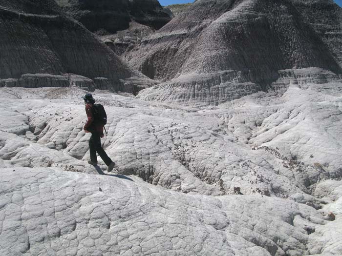
From Kachina Point at the PDI, which overlooks the wilderness area, we had mapped out our route. First straight east, then turning north and following a line of red badlands monuments towards a white area. It seems so clear from above, but once on the desert floor everything changes. A straight line is impossible, the easiest route is often going around or backwards. A sharp drop off proves, once you have walked to the edge, to have a series of smooths ramps down. A flat area suddenly ends in a cliff of capstone, forcing retreat and a way around. A dry wash provides easy walking despite its serpentine path, until it meanders off in the wrong direction.

My left knee, which had been giving me trouble from time to time, was now beginning to ache pretty constantly. A year ago I had surgery on the right for a torn meniscus and had been a bit dissatisfied with the results. Now I appreciate how well it feels compared to my left. I suspect I have torn my other menicus and am trying to go easy on it (getting older means finding out more than you want to know about body parts you didn't even know you had). This is frustrating as John nimbly makes his way through the obstacle course and I, wimpily, seek out the less challenging routes.

But as we walk across the desert, over rocks, dry washes, small buttes, clay and red sand I realize we make a good team. John's eyes are looking to the distance, planning our route. Mine are, as usual, beachcombing, noticing the minutiae. Flowers springing up from bare mud. A Darkling Beetle tipping off balance as he runs away. Pronghorn tracks, or maybe deer (but that wouldn't be as fun), in the dried mud. A piece of clear quartz embedded in the side of the wash. Saltbush seedlings. The tracks of a little creature.


We reach the large formations where we turn north and skirt their base, dipping in to explore interesting caves along the way. The wall ends at Lithodendron Wash where the vegetation grows unusually tall. Banks of shale that had split in cubist style are softened at the curve where the water sometimes rushes by. John decides to explore our options as I take advantage of the seating offered by the squared off rocks and pull out my watercolor kit. He comes back before I have gotten too far though, and we set off over powdery red dunes, anchored by grasses and punctured by subterranean habitats of mouse or snake.
  
Here and there lay huge petrified logs, amazing in their detail.


When we reach our destination, the white place, it is a surreal landscape. Hoodoos and formations look like they have been spray painted white.


 As always, I check out the drainages. These are crunchy ones, white on the bottom with crusty red topping. Eventually they narrow as to be impassable.


We agree that this moonscape had capped our hike, and start back, this time following Lithodendron Wash and its tributaries back to the trailhead. We had hiked for 5 1/2 hours, an hour shorter and longer distance than the last hike in the wilderness. It was good to get home and take off the hiking boots.

• • •

After I had showered and John was taking his, I'm working at my desk and hear a small thump. I look over and see a chubby mouse with a short tail and let out a small yelp. In my defense, he is just as startled as I am, and runs under the couch. We we first moved in we had noticed mouse droppings on the top of the fridge (how DID they get up there?) so were already storing most of the food inside the fridge, but we will have to be more vigilant. Otherwise, I'm sure I can share quarters with him for a couple of weeks.

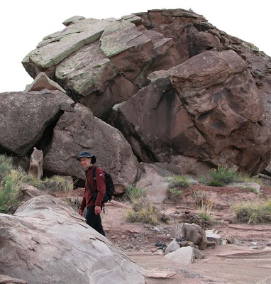
It is still rather early, so I decide to go to headquarters to do my laundry, gas up the car for the long drive to Phoenix and chat with some rangers. Then after a dinner of rice and beans we drive to the southern end and the Tepees to see how they look in the evening light, and give John one more look before he leaves in the morning.


Friday, April 27, 2012

The park road doesn't officially open till 7am, so by then we were on the road to the Tepees formation in the southern end of the park. The road crosses Route 40 on an overpass after which a vast grassland promises sightings of Pronghorns, but though I've seen plenty of tracks, I've yet to spot one. After a bit, the road crosses over the Santa Fe railroad tracks. Every few minutes trains with 3-5 locomotives come into view down the long straight tracks pulling a hundred or more cars, stacked 2-up with shipping containers. That might explain the rush-hour of trucks that lasts all day and night on Rt. 40.
After a few "Points of Interest" the tops of the Tepees come into view, then the road swings down and offers two pullouts. We park at one and head for two huge formations on the west side. As we pass the second one, we notice at its base an interesting drainage with wall of light cobalt green, blue, ochre and red in fascinating textures and shapes.  It reminded me of the drainages I loved in the Badlands NP where every sharp turn revealed something wonderful. It isn't a long drainage, the passable route ends with a tumble of boulders and tumbleweed under an arch of mudstone. With the rain yesterday, we speculate that collapse could come at any time and retrace our steps out of the drainage to view its continuation from above, which looks like a scale model of the badlands. That's why it's so hard to just distance here, a badlands formation can be 10 inches high or 100 feet. It looks the same. It's a fractal world out here.


We cross the road and head for the "tepees" to see how far into, or over them, we can get. The tepee shaped monuments are banded with blue and red and crowd together to form a wall, too steep and smooth to climb. We head between them where zigzag drainages of a different sort allow access in single file between the monuments. I keep thinking our path will narrow but instead, several join and the path continues a gradual climb till we come out on the top. From there are great 360 views, and great treasures at our feet. Shards of petrified wood, as colorful as the examples in the park's celebrated "Crystal Forest", and sheets of mica emerge from the mudstone, all glittering in the sun. Other petrified wood looks like the aftermath of a log-splitting frenzy, the same colors and textures as firewood, but hard as stone
.


We follow the summits south. Much of the surface is covered with a brown crust, like the frozen chocolate eclair bars I had as a kid. There are also many sinkholes that I give wide berth. I'm not sure how far you would go if you were to step into one but I know they empty out in little caves below, so I'm not taking a chance. Spotting a group of hoodoos we hike to them. They had looked so high we are surprised to be able to climb right next to them and joked about giving the precariously balanced ones just a little push. (We didn't). From there we look towards a mesa wall and consider hiking along it, later we realize that it is actually Blue Mesa that we are looking at from below. Instead we look for a way down and once again, the drainages are the best route. This one is bluer and its bed is mucky and slippery, due to the rain the day before. It soon encrusts our boots with badlands cement.


At night we take a moonlit walk up to Chinde Point. Even it was only 1/2 full, we barely need to use the flashlight. I'm looking forward to seeing the full moon on my last night here.


Thursday, April 26, 2012


Today I meet with the Artist in Residence Coordinator to talk about my public program at 11am, so I have some time in the morning to continue to work on the painting I started outside yesterday.  Rain is in the forecast, so an all day hike was probably not in the plan anyway, and we need to go into Holbrook soon for supplies, so today will be dedicated to practical matters.

I have a good, though short, meeting with the coordinator, Pat Thompson, who is also Chief of Resource Management and I expect has a pretty tight schedule. I had scoped out all the public points of interest in the park for my charcoal sketching class without finding one that would be practical. She suggests the courtyard at headquarters. While it would be convenient, the large courtyard, designed as part of the Mission 66 upgrade project for the national parks, is blocked from the landscape with buildings on all four sides and is about as stark a place as designed in the 60's. "But what will we draw?" I asked. She was probably thinking it would more like the cultural demonstrations the park offers.

I like to get people out into the landscape though, so I suggest the Rainbow Forest Museum at the southern end of the park. Even though I had been too wiped out to explore it when we took our park survey the first day, I figured I'd take a chance there'd be SOMETHING to draw there.

The class is scheduled for my last day, which meant I was free till then. Every residency is different and I realized that this was going to be a very independent one, which was fine by me, two weeks of unscheduled time to explore and work is luxury. 

After I get back we decided to take the southern route to Holbrook which would take us out the Rainbow Forest gate and give me a chance to check it out. But by the time we drove the 25 miles though the park the weather was getting chilly and the wind was picking up. We walked just enough of the Giant Logs trail, a hilly paved loop past big petrified logs, to figure it would be a good place for class. It was right next to the museum building, had places to perch or we could use chairs from the Museum, and if the weather made working outside difficult, students could actually sit in the museum and see the landscape out the big picture windows.

I talked to Dave in the museum about the class and he was enthused and helpful. With that taken care of, we headed back to the car just as the rain started.  The cold windy rain lasted through our grocery shopping, and a stop at the hardware store for a putty knife to substitute for the palette knife I had forgotten to bring. But by the time we arrived back at the park, the skies were clearing. We were very happy with our timing!

I walked across the street to Kachina Point to watch as slivers of sun traveled over the desert badlands, until it was the shadows which were the slivers in the brilliantly lit landscape.


After all that, we did manage to get a hike in. At Chinde Point lookout John walked out onto the spine of a one of the mounds below.


 From which he saw a strange monolith rising from the flat desert.


Of course we had to go see it, steep as the climb down was. A bonus were these strangely bonelike rocks, set out as if a huge dinosaur had expired on the spot.